A Diverse Landscape
The Salinas River, located in San Luis Obispo and Monterey Counties, flows northward between the Gabilan and Santa Lucia Mountains, and eventually flows into Monterey Bay. The watershed of the Salinas River covers almost 4,200 square miles. Mission San Miguel is located adjacent to the floodplain of the upper Salinas River. The two major tributaries to the Salinas River, the Nacimiento River and the San Antonio River, each have confluences with the Salinas River downstream (south) of Mission San Miguel. The Nacimiento and San Antonio River watersheds together cover about 705 square miles from their headwaters in the Santa Lucia Mountains to their confluences with the main stem of the Salinas River.
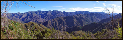
The San Antonio River flows from its headwaters between Cone Peak and Junipero Serra (aka Santa Lucia) Peak, through the Ventana Wilderness of the Los Padres National Forest, the Fort Hunter Liggett Military Reservation, and the lower San Antonio Valley, draining into man-made Lake San Antonio. The discharge from Lake San Antonio flows into Salinas River near Bradley in southern Monterey County. Historically the San Antonio River was prime habitat for stealhead trout. Steelhead are anadromous fish, spawning in rivers and living their adult lives in the ocean. Adults migrate upstream in order to spawn. After hatching, the young stealhead fingerlings migrate down to the ocean, completing the cycle. However, since the construction of the San Antonio Dam, which is a barrier to migration, steelhead spawning habitat is now damaged and limited.
Geologically, the San Antonio Valley is located on the Salinian Block of the Pacific crustal plate. The Salinian block is west of the San Andreas Fault and is composed largely of granite, which was originally connected to the basement rock of the Sierra Nevada Mountains and the Peninsular Ranges of Baja California. The lower watershed occupies the Lockwood basin, located between the santa Lucia Mountains and the Los Ojitos and San Ardo Hills. The sedimentary rocks, overlying the granitic basement, are largely composed of the Monterey Formation. The Monterey Formation is composed of shale formed in the ocean during the Miocene Epoch, between 17 and 5 million years ago.
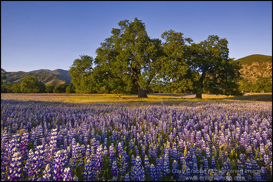
The San Antonio Valley is also known as the Valley of the Oaks. The Valley of the Oaks contains oak woodland, mixed oak and conifer forests, chaparral and grasslands plant communities. The valley is known for its endemic and stately Jolon Oaks, which are a hybrid between Valley Oaks and Blue Oaks. The hillsides, prairies and oak savannas are known for vast and diverse wildflower blooms during the spring. Wildlife is abundant, including ground squirrels, rabbits, deer, coyote, and even bobcats. Biird life is also very diverse, including songbirds, swallows, quails, turkeys, ravens, magpies, hawks and owls. It is not uncommon to see bald eagles and large herds of tule elk in the Valley of the Oaks.
Wildlife information: http://www.cawatchablewildlife.org/viewsite.php?site=114&display=q
California Native Plant Society: http://montereybay.cnps.org/
wildflowers: http://salinantribe.com/?page_id=113